Donegal County Council has won the Esri Storymaps accolade for the “The Hills of Donegal” 3D Map at the International User Conference, San Diego.
Esri revealed the winners of its Storytelling with Maps Contest yesterday at the Esri User Conference, highlighting Donegal County Council’s Story Map – “The Hills of Donegal” by Daragh McDonagh as third place in the Best Travel, Destinations, and Recreation section.
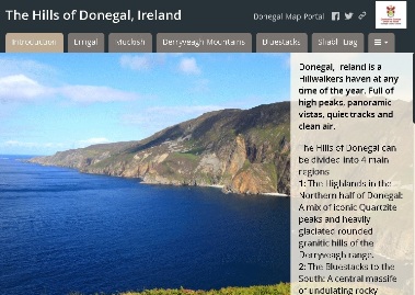
The Hills of Donegal Story Map which won a prestigious accolade from ESRI
From the iconic quartzite peak of Errigal to the spectacular sea cliffs of Sliabh Liag, Donegal has a wealth of upland areas to explore on foot. Daragh’s map takes the viewer on a 3D tour of the main mountains, with pre-set views from different angles. He even included weather forecast data to add some interactivity to the 3D landscape.
The Story Map encourages you to “pack your bags and lace up your boots after you see the hills of Donegal, Ireland from a whole new 3D perspective” says Esri in their assessment of this entry.
Storytellers from around the world submitted more than 400 entries that covered the full gamut of Esri Story Map templates. Contest judges selected 18 story maps as winners from across the five contest categories.
Submissions were judged on a range of factors. Each selected story map combined design, user experience, impact, and overall creativity with an interesting and engaging story.
All winners will receive a plaque and a certificate in honour of their award-winning story maps.
Brian Boyle, Head of Information Systems with Donegal County Council is delighted with this recognition for the Councils GIS function and in particular for the accolade bestowed on Daragh McDonough saying “Donegal County Council has been to the fore in exploring the potential of GIS as a tool for delivering more effective and efficient public services. Using GIS and story maps to promote and provide useful information on the county’s unique uplands and mountainous regions gives potential visitors an opportunity to sample the wonderful and exhilarating experience that awaits them on their visit to Donegal”.
Select an option below